Things to do
K50 Waterfall (Hang En) from Pleiku: location and season
Which commune K50 Waterfall (Hang En) belongs to after the merger, how far it is from Pleiku, who to register with, the road in, the best months and safety notes.
By Vương Nguyễn and teamRechecked
Published · 11 sources ↓
On this page
- Where K50 Waterfall is and which commune it belongs to
- From Pleiku to K50: distance and route
- Who to register with before you go
- How long the walk is and what the road in is like
- What the waterfall looks like and why it is called Hang En
- Which months are best
- Safety notes and who should skip it
- If you do not have time for K50
Hang En Waterfall is a long way out, needs registration with the nature reserve, and the way in has changed a lot over the years, so treat it as a trip of its own rather than one more stop in a busy day. Sort those things out before you leave and the rest, from choosing the month to packing, gets easy. If your time is short, things to do around Pleiku has places much closer to town.
Where K50 Waterfall is and which commune it belongs to
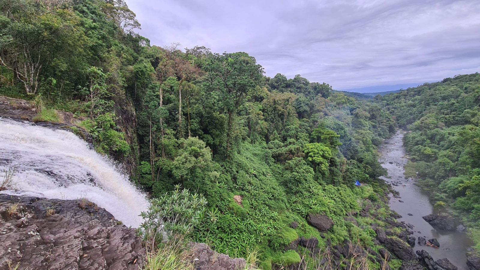
K50 Waterfall, also called Hang En, lies deep in the core zone of Kon Chu Rang Nature Reserve, in Son Lang commune (xa Son Lang), old Kbang district, about 70 km north of Kbang town (thi tran Kbang). It sits near the border of Gia Lai and Binh Dinh, on the upper Con River (song Con), whose water runs down from Gia Lai into An Toan commune (xa An Toan), An Lao district, Binh Dinh.
The commune name did not change, but its boundaries did. Resolution 1664/NQ-UBTVQH15 merges the whole area and population of So Pai and Son Lang into a new commune called Son Lang (clause 66), applied from 1 July 2025. So when you look up a phone number or ask a local, say “xa Son Lang”; “Kbang district” is what you will keep seeing in older articles.
The People’s Committee of Gia Lai province has recently recognised Kon Chu Rang Nature Reserve in Son Lang as a tourist site, so it is no longer a place only trekkers know. Even so, the way in is still forest, and you should go in the spirit of an expedition, not a roadside photo stop.
From Pleiku to K50: distance and route
From central Pleiku it is about 150 km to the fall, which means a whole morning just to reach the edge of the reserve, before the last stretch in. The usual route is Highway 19, then the Truong Son Dong road to Kon Chu Rang Nature Reserve. From Kbang town there are still about 70 km to go, so fill the tank, have breakfast and buy water in Kbang before the quiet part of the road.
We recommend you do not try to ride there and back in one day on a self-driven motorbike unless you know forest roads and passes: that distance plus the way in can easily get you home after dark. It works better to leave very early, or to sleep one night in Kbang and set off the next morning. If you need a bike, how to rent a motorbike in Pleiku will help you settle it before the day.
Who to register with before you go
You cannot just walk in: before you go you must book and register with the Kon Chu Rang Nature Reserve rangers, and the most important job is a careful look at the weather forecast so the trip is not interrupted. Tour companies do the same paperwork with the reserve’s management board when they arrive, before going on.
The contact point is the management board of Kon Ka Kinh National Park, the unit given the job of running, operating and developing this tourist site (news of 18 August 2026). Ask them about the entry fee, the hours they receive visitors, guides, and whether you can go independently or must join a group. We recommend calling a few days ahead rather than at the last minute: if the weather turns or the group is full, you still have time to change the date. Group sizes vary too; one tour lists 20 to 25 guests with a national park supervisor.
If you want forest closer to Pleiku, Kon Ka Kinh National Park is the next best choice.
How long the walk is and what the road in is like
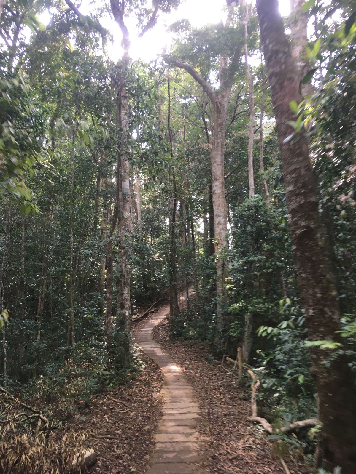
The way in has changed a lot over the years. In the past, from the reserve gate you walked through primary forest, along trails, across streams and rocky rapids, about four hours, nearly four hours of forest trekking over 8 to 10 km, a real test with small children.
Now there are more concrete roads that let motorbikes get close to the foot of the fall, and from where the road ends it is about 20 minutes on foot. The tour companies offer two ways: one picks guests up in a pickup truck and then a special vehicle for a 7 km journey, another leads a 5 km trek through the forest with rangers and a guide.
These three options ask very different things of your legs, so when you register ask directly which sections you can ride, which you must walk, and roughly how long it takes. If you are going with older people or small children, ask too whether there are rest spots on the way.
What the waterfall looks like and why it is called Hang En
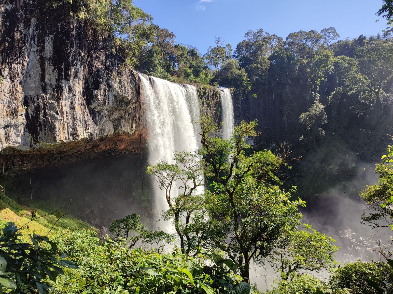
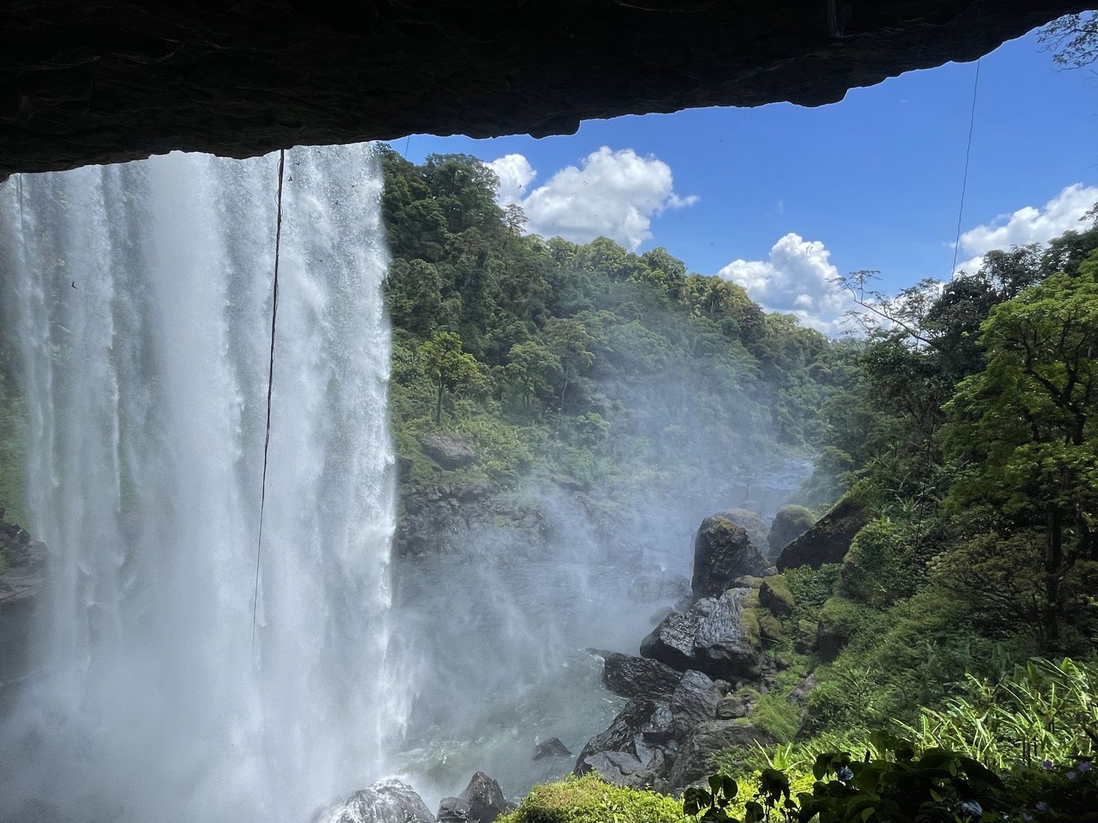
The fall is about 54 m high and 20 to 100 m wide, water pouring hard from inside the mountain into the stream bed and throwing up white spray like a silk ribbon across the forest. The width varies with how much water there is in the season, so the same fall can look different each time you come.
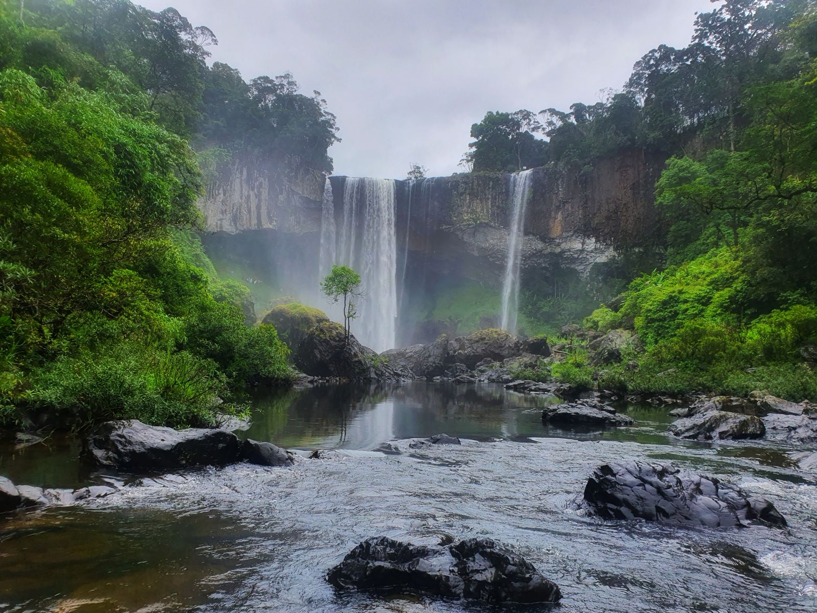
As for the name, “Hang En” (swiftlet cave) comes from the cave behind the water where many swiftlets live, while “K50” refers to the fall’s height of just over 50 m. The photo taken from the hollow behind the water curtain shows the view out to the forest and sky; if you like photos, it is worth the extra time.
The fall is part of the upper Con River. At a meeting on 23 June 2026 to hear a report on the province’s eco-tourism project, conquering K50 and K40 waterfalls and kayaking and SUP on the Kon River (song Kon) were among the main products planned for the area. That means the way to reach the fall may change again, one more reason to check before you go.
Which months are best
The best window of the year is January to June, with warm, dry weather and little rain without being parched. We recommend choosing within it, because outside the dry season the forest paths are slippery and trips are easily cancelled.
In the dry season the pool at the foot is shallower and shows rocks of many shapes, which gives you room to walk and take photos around the base. Whatever month you pick, check the forecast carefully just before the day, because this is a long trip and hard to reschedule.
Safety notes and who should skip it
The trekking programme to the fall is not advised for people with a history of high blood pressure, low calcium, asthma, heart disease, epilepsy and other chronic illnesses. If you or someone in your group is in that list, we recommend a fall closer to town such as Xung Khoeng Waterfall or Phu Cuong Waterfall.
The path is not very hard but has many tall rocks, so go slowly and carefully. If you want to camp, choose flat, non-slippery ground. If it rains, stop and wait rather than push on, because the whole reserve is forest and stream.
On the risk along the way: on 3 July 2024 a woman visitor died on her way in to the fall. The group was riding motorbikes driven by local people, and at the Suoi Cat slope (doc Suoi Cat) a forest tree about 20 cm across fell on her. It is a rare accident, but it reminds you to keep to the schedule you registered with the reserve and to avoid wet, windy days when trees fall more easily.
If you do not have time for K50
At about 150 km and with registration needed in advance, K50 does not suit anyone with just one morning or afternoon. If you want a waterfall and still want to be back for dinner in town, look at Xung Khoeng Waterfall or Phu Cuong Waterfall, and weekend trips near Pleiku lines up many places by distance. Keep K50 for a relaxed full day, or one night away, and you will find the distance worth it.
Questions
Where is K50 Waterfall and which commune is it in?
K50 Waterfall (Hang En) sits deep in the core zone of Kon Chu Rang Nature Reserve, in Son Lang commune, near the border of Gia Lai and Binh Dinh. On 1 July 2025 So Pai and Son Lang merged into a new commune that is still called Son Lang, so use that name when you ask directions or make contact.
How far is K50 Waterfall from Pleiku?
About 150 km from central Pleiku. You take Highway 19, then the Truong Son Dong road to Kon Chu Rang Nature Reserve. Because it is so far, plan a full day or an overnight stay, not a short morning.
Who do I register with to visit K50 Waterfall?
Book ahead and register with the Kon Chu Rang rangers, and check the weather forecast carefully. The management board of Kon Ka Kinh National Park is the unit assigned to run and develop this tourist site, so ask them about entry fees when you register.
How long is the walk to K50 Waterfall?
An older account says nearly four hours on foot, over roughly 8 to 10 km. Concrete roads now let motorbikes reach close to the foot of the fall, leaving about 20 minutes on foot. The way in changes often, so ask again when you register.
Which month is best for K50 Waterfall?
January to June is the best window: warm, dry, little rain without being parched. In the dry season the pool at the foot is shallower and shows rocks of many shapes.
Why is K50 Waterfall also called Hang En?
Behind the water is a cave where many swiftlets live, which gives the name Hang En (swiftlet cave). K50 refers to the fall's height of just over 50 m; other reports give about 54 m.
Read next
Sources
(11)
- Thác K50, nàng thơ của Tây Nguyên (Báo Dân tộc và Phát triển) (K50 Waterfall, muse of the Central Highlands)
- Toàn văn Nghị quyết số 1664/NQ-UBTVQH15 sắp xếp các ĐVHC cấp xã của tỉnh Gia Lai năm 2025 (Resolution 1664/NQ-UBTVQH15, full text)
- Thác K50 mùa đẹp nhất (VnExpress) (K50 Waterfall in its best season)
- Chinh phục thác Hang Én (Báo Nhân Dân, 07/06/2024) (Conquering Hang En Waterfall, 7 June 2024)
- Thác K50 và những bài học vô giá (Báo Gia Lai) (K50 Waterfall and its priceless lessons)
- Công nhận Khu bảo tồn thiên nhiên Kon Chư Răng là điểm du lịch (Báo Gia Lai, 18/08/2026) (Kon Chu Rang Nature Reserve recognised as a tourist site, 18 August 2026)
- Tour thác K50 - thác K40 - Hang Én - Kon Chư Răng (Gotour Gia Lai) (K50 - K40 waterfalls, Hang En, Kon Chu Rang tour)
- Tour thác K50 - thác Hang Én (Tổ Ong Adventure) (K50 - Hang En waterfall tour)
- Nàng thơ Tây Nguyên: thác K50 vào mùa đẹp nhất (Báo Gia Lai) (Muse of the Central Highlands: K50 at its best)
- Kbang: Vào thác K50 chơi, 1 người phụ nữ bị cây ngã đè tử vong (Báo Gia Lai, 03/07/2024) (Kbang: woman killed by falling tree on way to K50, 3 July 2024)
- Gia Lai họp nghe báo cáo đề án du lịch sinh thái tại Kon Ka Kinh và Kon Chư Răng (Báo Gia Lai, 23/06/2026) (Gia Lai meeting on eco-tourism project at Kon Ka Kinh and Kon Chu Rang, 23 June 2026)
Photos
(5)
Quý Trần Bá · Phạm Anh Vũ · Thắng Trịnh · Anh Ha · le ngocvang
Spotted an error? Send a correction · How we choose sources